répartition, pyramides des âges, IDH, inégalités, cartes.
La population mondiale :
The International Data Base (IDB) is a computerized data bank containing statistical
tables of demographic, and socio-economic data
for 227 countries and areas of the world. Total count of Independent
States: 192
horloge de la population mondiale :
http://www.census.gov/cgi-bin/ipc/popclockw
prévisions : d'après l'ONU, la terre accueillera 9,1 milliards
d'êtres humains en 2050, soit 2,6 milliards de plus qu'en 2005.
http://www.un.org/esa/population/publications/WPP2004/WPP2004-HIGHLIGHTS_Final.pdf
sources :
Institut national des études démographiques
http://www.ined.fr
Institut national de la statistique et des études économiques
http://www.insee.fr
rapport ONU : sur le développement :
http://www.unfpa.org/swp/2005/francais/ch1/index.htm
statistiques :
http://stone.undp.org/hdr/reports/global/2004/francais/pdf/hdr04_fr_HDI.pdf
Census américain http://www.census.gov
prévisions sur la population (en anglais)
LA REPARTITION DE LA POPULATION MONDIALE :
des pays ;
http://www.clio.fr/BIBLIOTHEQUE/pays.asp
Le monde la nuit :
http://earthobservatory.nasa.gov/Newsroom/NewImages/Images/earth_lights_lrg.jpg
=> ex comparer l' Europe de l'ouest avec la Chine et l'Inde.
Etude de cas, les Etats Unis :
popu Etats Unis :
http://hgtice.free.fr/carto/cartohis.htm#internet
répartition de la population aux Etats Unis :
http://sedac.ciesin.org/plue/gpw/index.html?no_america.html&2
carte du relief :
http://teacherlink.ed.usu.edu/tlresources/clipart/maps/namericaphys.JPG
carte du climat :
http://www.homestore.com/homegarden/gardening/landscaping/zones/climate/index.asp?poe=homestore
carte historique du peuplement :
http://www.perno.com/history/lessons/art/settlement.gif
immigration :
http://www.ellisisland.org/
Peopling of America : le peuplement des Etats Unis par périodes
Family Histories ex : paper sons
centres d'immigration pour les Asiatiques sur la côte ouest :
http://www.angelisland.org/immigr02.html
cliquer aussi sur IS images
évolution de la population de 1990 à 2000 : carte
http://quickfacts.census.gov/qfd/maps/thematic/PL0120000.html
tableau de la population d'après le recencement : en pourcentage
http://quickfacts.census.gov/qfd/states/00000.html
carte de la pauvreté aux Etats Unis :
http://factfinder.census.gov/servlet/ThematicMap
à Los Angeles :
http://factfinder.census.gov/home/saff/main.html?_lang=en
cas de la frontière USA/Mexique :
http://www.amnestyinternational.be/doc/article2317.html
rapport sur l'obésité :
http://www.who.int/dietphysicalactivity/publications/facts/obesity/en/
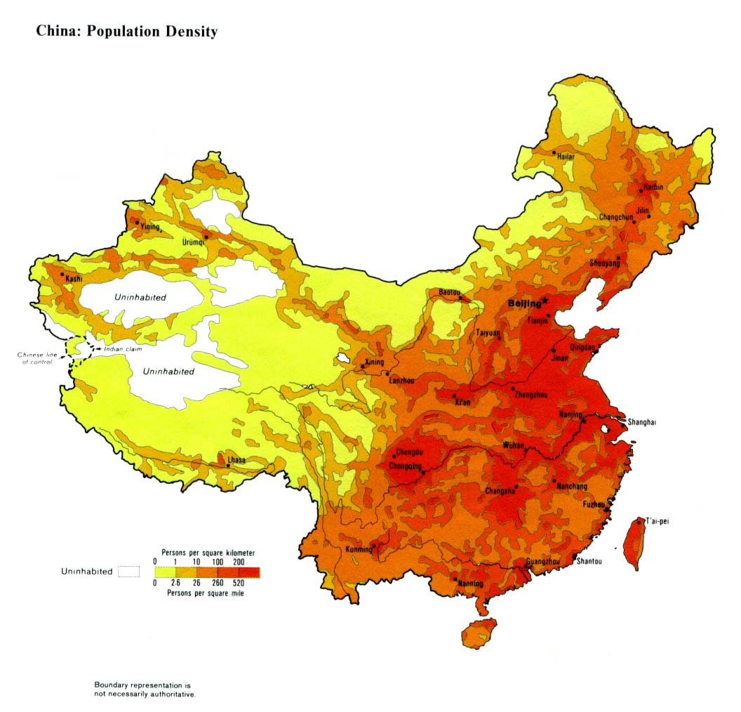
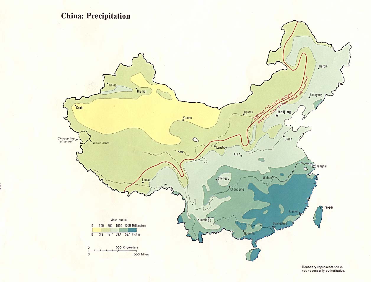
Etude de cas, la Chine
répartition de la population en Chine :
http://www.lib.utexas.edu/maps/middle_east_and_asia/china_population_83.jpg
le relief :
http://forages.orst.edu/maps/china/PRC-PhysChar-Elevation-1km-Shaded.jpg
carte des précipitations :
http://www.lib.utexas.edu/maps/middle_east_and_asia/china_precip.jpg
[TP sur le barrage des Trois Gorges : et ensemble
de liens :
http://www.clionautes.org/article.php3?id_article=581
plus de 6 milliards d'hommes :
chiffres de la population mondiale :
http://www.ined.fr/population-en-chiffres/monde/index.html
population et société : bilan par continent :
http://www.ined.fr/publications/pop_et_soc/pes392/392.pdf
PYRAMIDES DES AGES DES PAYS DU MONDE
http://www.census.gov/ipc/www/idbpyr.html
http://fisher.lib.virginia.edu/collections/stats/histcensus/
vocabulaire :
http://www.arte-tv.com/fr/histoire-societe/Du_20baby-boom_20au_20papy-boom/Glossaire/694396.html
Les inégalités Nord Sud dans le monde :
http://www.liberation.fr/page.php?Article=48825&Template=GALERIE&Objet=1268
IDH
UNFA (United nations population Fund): http://www.unfpa.org
State of World Population 2004 :
http://www.unfpa.org/swp/2004/francais/ch1/index.htm
rapport su le développement humain :
http://hdr.undp.org/
sources PNUD : rapports sur le développement humain par pays :
http://hdr.undp.org/statistics/data/
Amartya Sen à l'origine de l'IDH, historique
http://hdr.undp.org/reports/global/1990/
ONU et IDH :
http://hdr.undp.org/reports/global/2004/francais/
http://hdr.undp.org/reports/global/2004/pdf/hdr04_HDI.pdf
calcul de l'IDH :
http://www.ac-rouen.fr/pedagogie/equipes/ses_net/ses_ped/ses20112.htm
Dubaï :
http://guide.theemiratesnetwork.com/living/dubai/the_palm_islands.php
cartes ONU pb réfugiés, santé
http://wwww.reliefweb.int/w/map.nsf/home
projet contre la faim dans le monde : ex. indien
http://64.224.173.9/french/index.html
cartes par continents : http://www.cia.gov/cia/publications/factbook/docs/refmaps.html
Des cartes de géo :
http://www.atlas-historique.net/recherche-thematique.html#GM2e
reportage photos : http://www.lexpress.fr/express/reportages/
Quelques villes dans le monde:
images satellitales